Contact Windows Support

  • Subscribe to our RSS feed.
  • Twitter
  • StumbleUpon
  • Reddit
  • Facebook
  • Digg

Friday, 17 December 2010

Under the hood of Google Maps 5.0 for Android

Posted on 10:50 by Unknown
(Cross-posted from the Official Google Blog)

Yesterday we introduced Google Maps 5.0 for Android with two significant new features: 3D interaction and offline reliability. In order to create these features, we rebuilt Maps using vector graphics to dynamically draw the map as you use it. Building a vector graphics engine capable of achieving the visual quality and performance level you expect from Google Maps was a major technical challenge and enables all sorts of future possibilities. So we wanted to give you a closer look under the hood at the technology driving the next generation of mobile maps.

Vector graphics
Before diving into how Maps uses vector graphics, it may be helpful to understand how maps were created before. Previously, Google Maps downloaded the map as sets of individual 256x256 pixel “image tiles.” Each pre-rendered image tile was downloaded with its own section of map imagery, roads, labels and other features baked right in. Google Maps would download each tile as you needed it and then stitch sets together to form the map you see. It takes more than 360 billion tiles to cover the whole world at 20 zoom levels!

Now, we use vector graphics to dynamically draw the map. Maps will download “vector tiles” that describe the underlying geometry of the map. You can think of them as the blueprints needed to draw a map, instead of static map images. Because you only need to download the blueprints, the amount of data needed to draw maps from vector tiles is drastically less than when downloading pre-rendered image tiles. Google Maps isn’t the first mobile app to use vector graphics—in fact, Google Earth and our Navigation (Beta) feature do already. But a combination of modern device hardware and innovative engineering allow us to stream vector tiles efficiently and render them smoothly, while maintaining the speed and readability we require in Google Maps. Just try it out and see for yourself!

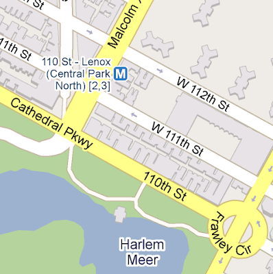
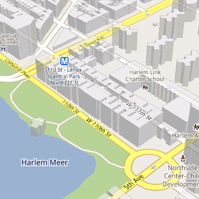
See the difference between image tiles (left) and vector tiles (right) tilted to show 3D buildings.

One map, many perspectives
Using vector tiles instead of image tiles gives Maps the flexibility to re-draw the same map from different perspectives using the same set of data. Zooming is one example of this at work. If you magnify an map image tile by 2x, lines such as roads and text would get twice as wide and appear blurry. As a result, we had to constrain Maps to 20 fixed “zoom levels,” each one twice as close as the last. Every time you zoomed in further, you’d need to download a completely new set of image tiles. It took time to load new data over a mobile data connection, and would fail when you lost your connection in a subway or large building.

Compared to image tiles (left), vector tiles (right) keep lines and labels crisp as you zoom.

With vector graphics, you no longer need to “round” to the nearest zoom level and then download all the tiles for that level. One vector tile has the underlying vector data (or blueprints) to draw the map at many different levels of scale. So when you zoom, the map stops when your fingers stop, and roads and labels always stay crisp. This same technique powers the new 3D map interactions: tilt, rotate and compass mode. Just like with zooming, Maps uses the same vector data to draw the map from any angle or direction as you tilt or rotate.

We can also display entirely new levels of detail that weren’t possible with flat image tiles. For example, in the 100+ cities where we have 3D building data, each building is drawn in 3D using a polygonal building footprint and heights for different parts of the building. And with tilt and rotate, you can see them from a variety of different angles.

Reading the map
Just like other map features, labels are dynamically drawn so they continue to face you and stay legible if you rotate the rest of the map or use compass mode. Maps also “chooses” the best labels to show you based on several factors. You’ll notice labels fade in and out as you interact with the map so that the most useful ones appear and the map never gets too cluttered.

See the difference between rotating maps with static labels (left) and dynamic labels (right).

Vector graphics also allow us to draw additional data on the map more clearly. For example, traffic or transit lines no longer block the labels beneath them. We can also draw the same map in different styles — like “satellite view” where the roads are translucent over aerial imagery, or Navigation’s “night mode” where a darker palette helps your eyes adjust quickly in the lower light.

Previously, map features like labels and traffic could conflict (left) instead of blend seamlessly (right).

Offline reliability
Vector graphics also enable another significant new feature: the ability to continue viewing maps even when you have poor—or no—network connections. Because each vector tile works across multiple zoom levels, it requires more than 100 times less data to view maps across all zoom levels than before, allowing Maps to cache much larger areas of the map on your device.

With this first version, Maps proactively caches map data for the places you use Maps the most—where you’re actively using it as well as places for which you search or get directions. Then when you’re plugged in and connected over WiFi, caching happens automatically. Near your frequent places, you’ll get detailed vector tiles for city-sized regions so you can see every road labeled. Further away, you’ll have less detail but will typically have towns and highways labeled for miles. We’re continuing to work on these algorithms, so you’ll see improvements over time.

Offline rerouting
With Google Maps Navigation (Beta), you’ll also see the benefits of additional caching with offline rerouting. This feature is only possible because Navigation caches not only map data but also data like turn restrictions for the areas surrounding your route. You’ll still need to be connected when you first start a trip to download and cache your route. But this way, even if you take a wrong turn after losing your connection, Navigation can use the cached data to get you back on your way. We will be rolling this feature out gradually over the next few weeks.

This is just the start, and we’re really excited about all the possible ways to use vector graphics technology for the next generation of Google Maps. So please stay tuned!

Update (12:47pm PST): Tweaked the description of the difference between image maps zoom levels.

Posted by Andrew Miller, Software Engineer, Google Maps for mobile
Email ThisBlogThis!Share to XShare to FacebookShare to Pinterest
Posted in android, google maps for mobile, google maps navigation | No comments
Newer Post Older Post Home

0 comments:

Post a Comment

Subscribe to: Post Comments (Atom)

Popular Posts

  • Happy New Year!
    Posted by Lawrence Chang, Product Marketing Manager, Google mobile team When I first asked the mobile team to send me pictures of how they r...
  • XMAS TIME - Get a Lumia 925 for free
    Do you want a Lumia 925 for Christmas? Thanks to DVLUP you can get it easy :) Check the new xmas challenge ! You just need to create 3 new ...
  • Our 5 favourite new Windows Phone apps of the week
    Today myMoneyBook is featured in Nokia's blog:  Our 5 favourite new Windows Phone apps of the week . Thank you so much  Nokia !
  • Mobile Web Calendar for iPhone and Android, now with event management
    It's probably no news to all you parents out there, but as a new dad I only recently found out just how busy life gets with kids. So I w...
  • Windows Phone 8 - Map and Clusters
    This code example demonstrates how to dynamically group pushpins in the map control. There is a lot of code for Windows Phone 7, then I merg...
  • Places Directory app for Android
    As an engineer based in Taipei, I frequently travel to Google headquarters in Mountain View. When I'm there, I'm always looking for...
  • The Iterative Web App - Faster Address Auto-complete and Keyboard Shortcuts
    On April 7th, we announced a new version of Gmail for mobile for iPhone and Android-powered devices. Among the improvements was a complete...
  • Our newest Mobile Search feature: Where am I?
    Many of our improvements to search quality come from analyzing actual search queries. We’re constantly trying to surface more relevant sea...
  • [ITA] Dal 920 al Lumia 1020
    Che dire... Il Lumia 1020 subentra di prepotenza con il suo colore giallo. La prima impressione è sicuramente molto positiva, non solo per l...
  • Impressions of CES
    Posted by Lawrence Chang, Product Marketing Manager, Google mobile team As the 2008 Consumer Electronics Show winds to a close, some of you...

Categories

  • 100th post
  • 3D
  • 6210 navigator
  • 6220 classic
  • adsense
  • adsense for mobile
  • alexandra's mobile [ad]itude
  • Amber
  • android
  • android market
  • android widget
  • app
  • appdeals
  • apphub
  • apple
  • apps
  • att
  • autocomplete
  • best buy mobile
  • better know your mobile
  • biking directions
  • BlackBerry
  • BlackBerry Storm
  • blackjack
  • blogger
  • brightpoint
  • bug
  • buxfer
  • Buzz
  • buzz for mobile
  • c#
  • cab4me
  • Calendar
  • Caliburn
  • canada
  • CES
  • check-in
  • chi-2008
  • clearwire
  • cloud print
  • Clusters
  • Coding4fun
  • Contacts
  • convenience key
  • countdown to 2009
  • coupons
  • csharp
  • culture
  • dennis woodside
  • developers
  • Docs
  • Doodle
  • doodles
  • dotorg
  • doubleclick mobile
  • droid
  • DVLUP
  • e-series
  • ebook
  • election
  • enterprise
  • feature phones
  • france
  • free
  • g1
  • geo
  • geolocation api
  • germany
  • Gesture search
  • gmail
  • gmail for android
  • gmail for mobile
  • GOOG-411
  • googe search
  • Google
  • Google Africa
  • google analytics
  • Google Apps
  • Google Apps Blog
  • google apps device policy
  • google apps for mobile
  • google book search
  • google buzz
  • google buzz for mobile
  • Google Custom Search
  • google docs
  • google earth
  • google finance
  • google gears for mobile
  • google goggles
  • Google I/O
  • google instant
  • google latitude
  • google local search
  • Google Location Alerts
  • google location history
  • Google Locaton History
  • google maps
  • google maps for mobile
  • google maps navigation
  • google mobile
  • google mobile ads
  • google mobile help
  • google mobile help forum
  • Google Mobile Search
  • google mobile tips
  • google mobile tricks
  • google moderator
  • Google News
  • google offers
  • google product search
  • Google profile
  • Google public location badge
  • google search
  • google search app
  • google search by voice
  • google search for mobile
  • google shopper
  • google sites
  • google sky map
  • Google SMS
  • google suggest
  • google sync
  • google talk
  • google toolbar
  • google translate
  • google translate for animals
  • google voice
  • google wallet
  • google+
  • googlenew
  • gps
  • hangouts
  • history
  • honeycomb
  • hot
  • hotpot
  • html 5
  • i-mode
  • igoogle
  • image ads
  • image search
  • inside search
  • Interative web app
  • iOS
  • ipad
  • iphone
  • ipod touch
  • italy
  • iterative web app
  • Iterative Webapp
  • J2ME
  • jason spero
  • lambda
  • latitude api
  • layers
  • Listen
  • Local Business Center
  • local inventory
  • local search
  • locale
  • location based search
  • location tag
  • Lumia 1020
  • Lumia 925
  • mac
  • macworld
  • Mail
  • Maps
  • marketplace
  • mary meeker
  • meow me now
  • microsoft
  • mobile
  • mobile [ad]itude
  • mobile advertising
  • mobile calendar
  • mobile tricks
  • mobile world congress
  • mobile.google.com
  • moneybook
  • motorola
  • movies
  • music
  • MVVM
  • my location
  • my tracks
  • myBattery
  • mymoneybook
  • n-series
  • n78
  • n95
  • n96
  • navigation
  • new york city
  • nexus
  • nfc
  • nokia
  • Nokia Pro Camera
  • NowPlaying
  • ntt docomo
  • NuGet; Visual Studio
  • nyc
  • open handset alliance
  • opera
  • opera mini
  • opera mobile
  • orkut
  • outbox
  • palm
  • palm webos
  • Panoramio
  • personalized suggest
  • Picasa web albums
  • Place Pages for mobile
  • Places
  • Places Directory
  • pre
  • product ideas
  • product search
  • produt search for mobile
  • quick search box
  • Reader
  • registration
  • research
  • s60
  • samsung
  • santa
  • search
  • search by voice
  • Search Options
  • sharing
  • shortcut
  • sidekey
  • silverlight
  • sky lab
  • smart navigation
  • social
  • Sony
  • sony ericsson
  • spain
  • Spreadsheeets
  • sprint
  • sql ce
  • sqlite
  • starring
  • stars
  • street view
  • Summer Games
  • symbian
  • Sync
  • Syncfusion
  • t-mobile
  • tablet
  • tasks
  • TechNet
  • TechNet wiki
  • telerik
  • Thomson
  • TileView
  • tips
  • transit
  • uiq
  • uk
  • universal search
  • verizon
  • visual search
  • voice actions
  • voice search
  • vote
  • walking directions
  • walking navigation
  • web app
  • wep app
  • wikininjas
  • windows 8
  • windows mobile
  • windows phone
  • Windows Phone 7.8
  • Windows phone 8
  • windows RT
  • Windows Store
  • wireless week
  • xaml
  • xna
  • youtube
  • youtube channel
  • YouTube for mobile
  • zoho

Blog Archive

  • ►  2013 (21)
    • ►  November (3)
    • ►  October (1)
    • ►  September (3)
    • ►  August (3)
    • ►  July (2)
    • ►  June (4)
    • ►  April (1)
    • ►  March (1)
    • ►  February (2)
    • ►  January (1)
  • ►  2012 (32)
    • ►  December (2)
    • ►  November (3)
    • ►  October (3)
    • ►  September (6)
    • ►  August (1)
    • ►  June (1)
    • ►  May (2)
    • ►  April (3)
    • ►  March (5)
    • ►  February (5)
    • ►  January (1)
  • ►  2011 (98)
    • ►  December (8)
    • ►  November (9)
    • ►  October (6)
    • ►  September (7)
    • ►  August (2)
    • ►  July (12)
    • ►  June (7)
    • ►  May (11)
    • ►  April (8)
    • ►  March (12)
    • ►  February (9)
    • ►  January (7)
  • ▼  2010 (122)
    • ▼  December (18)
      • Dashing through the snow... with NORAD and Google
      • Android In Spaaaace!
      • Under the hood of Google Maps 5.0 for Android
      • The next generation of mobile maps
      • The wait is over: Announcing Nexus S availability ...
      • Voice Search gets personal
      • Google Voice app now supports iPad & iPod Touch
      • 你好, नमस्ते and bonjour to better mobile web Gmail
      • How to check your email from your phone (and 50 ot...
      • Introducing the Google Latitude app for iPhone
      • Trailblazing in Portland
      • Gmail for Android: better Priority Inbox support a...
      • Google Instant for mobile now available globally
      • YouTube 2.1 App Now Available on Android Market
      • Introducing Nexus S with Gingerbread
      • Discover more than 3 million Google eBooks from yo...
      • Google doodles for your phone
      • Ready... set... track Santa!
    • ►  November (10)
    • ►  October (8)
    • ►  September (10)
    • ►  August (10)
    • ►  July (4)
    • ►  June (11)
    • ►  May (7)
    • ►  April (14)
    • ►  March (13)
    • ►  February (10)
    • ►  January (7)
  • ►  2009 (109)
    • ►  December (7)
    • ►  November (14)
    • ►  October (14)
    • ►  September (6)
    • ►  August (7)
    • ►  July (9)
    • ►  June (13)
    • ►  May (10)
    • ►  April (7)
    • ►  March (7)
    • ►  February (11)
    • ►  January (4)
  • ►  2008 (92)
    • ►  December (11)
    • ►  November (7)
    • ►  October (9)
    • ►  September (6)
    • ►  August (6)
    • ►  July (11)
    • ►  June (12)
    • ►  May (4)
    • ►  April (8)
    • ►  March (5)
    • ►  February (5)
    • ►  January (8)
  • ►  2007 (9)
    • ►  December (6)
    • ►  November (3)
Powered by Blogger.

About Me

Unknown
View my complete profile